Severe weather is on the horizon for Baltimore this Sunday, and it could impact the plans for many celebrating St. Patrick’s Day. The National Weather Service (NWS) is warning residents about strong winds and the possibility of thunderstorms that could bring dangerous conditions throughout the day. With winds possibly reaching up to 58 mph, everyone is encouraged to prepare and stay informed as the storms evolve.
Weather Warnings for Baltimore
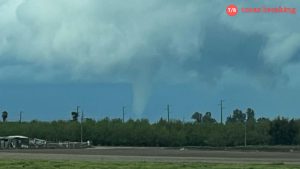
As we look ahead to Sunday, the forecast suggests that Baltimore and the surrounding areas could face severe storms blowing in from the southern United States. Meteorologist Kyle Pallozzi from the NWS highlights that high winds are the primary concern, which could lead to downed trees and power lines across the region. Though a tornado is possible, it is considered a lower threat compared to the high winds and storms that are predicted.
Important Details About the Storms
- Sunday’s temperatures are expected to range from 51 to 69 degrees.
- There’s a 90% chance of storms in the afternoon after a rainy morning, which has a 40% chance of precipitation.
- Some areas may see rainfall amounts between 0.5 to 2 inches, leading to a risk of flooding.
- Residents are urged to stay indoors during stormy weather to avoid lightning risks, waiting at least 30 minutes after the last lightning strike before going outside.
St. Patrick’s Day Events and Weather
This weekend is special for many in Baltimore due to St. Patrick’s Day festivities. However, officials advise that the celebrations may be disrupted by the severe weather. Events, including a 5K run and a parade scheduled for Sunday afternoon, could be impacted due to the approaching storms. Baltimore Gas and Electric Company also recommends preparing for potential power outages during stormy weather.
Preparing for Severe Weather
It is crucial for residents to be prepared for severe weather conditions. Here are some tips to ensure safety:
- Gather emergency supplies such as flashlights, batteries, and a fully charged power bank for electronics.
- Have nonperishable food and water ready in case of power outages or limited travel.
- Ensure your vehicle has a full gas tank in case evacuation becomes necessary.
- If a tornado warning is issued, seek shelter in a basement or interior room away from windows.
Stay Safe and Informed
As the storms move closer, it’s essential to stay updated with the latest weather forecasts. Residents should keep an eye on local news and heed any emergency alerts issued by the NWS. This storm is serious, so taking precautions is vital for everyone’s safety during this potentially dangerous weather. Make sure to check your emergency planning and be cautious if you have to travel this weekend.
What to Expect on Sunday
The weather will change throughout the day, with Sunday expected to be partly cloudy in the early hours, but storms will ramp up as we move into the afternoon. The storms may bring heavy rain and gusty winds that could impact travel and outdoor activities. If you plan to head out, it’s safest to delay your plans until Monday, when conditions are expected to improve.