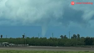
Stormy weather has taken center stage in Fresno and surrounding areas, causing buzz and concern among residents. On Monday afternoon, a series of intense thunderstorms led to the development of funnel clouds seen swirling in parts of Merced County. As the storms moved through Central California, officials acted quickly, issuing two tornado warnings to keep everyone safe.
Tornado Warnings in the North Valley
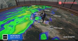
The National Weather Service wasted no time in responding to this unusual weather. Around 2:30 PM, meteorologists spotted a funnel cloud forming northeast of Atwater. Just minutes later, another funnel cloud emerged near Vine and Almond streets. These developments prompted warnings for Merced, Mariposa, and Tuolumne counties, indicating possible tornadic activity that could pose risks to those in the path of the storms.
Chief Meteorologist Kevin Musso reassured residents about the importance of understanding tornado watches and warnings. A tornado watch means conditions are favorable for storms to form, while a warning means a tornado has been sighted or indicated by radar. In times like this, finding shelter in sturdy buildings is crucial, Musso emphasized.
Wet Weather Continues across Central California
Following these alarming funnel cloud sightings, the storms brought heavy rain and even snowy conditions to the Central Valley and nearby mountains. Youngsters may find the snow exciting, but school closures in Madera County serve as a reminder to be cautious during wild weather. In the meantime, many communities across the valley will have to contend with the effects of more rain, which could lead to messy road conditions.
Looking Ahead: A Week of Fluctuating Weather
While severe weather made a dramatic entrance, the forecast for the upcoming week shows a calming trend. For instance, Tuesday is expected to start off cloudy but will brighten up with afternoon sunshine. Temperatures will reach highs of around 61 degrees, while nights will cool down to 41 degrees.
As we move forward in the week, the weather will gradually clear up, bringing partly cloudy skies with highs reaching 68 degrees by Wednesday. Really, it seems that after such an eventful start to the week, we can expect more typical spring temperatures as we approach the official start of the season on Thursday. With highs of 67 degrees and lows around 43, it’s time to put away those heavy winter coats!
As the days progress, residents can look forward to mostly sunny skies over the weekend. Saturday is expected to warm up to about 69 degrees, and Sunday might even nudge the thermometer up to 73! But remember, spring temperatures can shift, so always check the forecast.
Stay Updated!
These roller-coaster weather patterns remind us to stay alert and informed. Keep your local news radio tuned in, or visit trusted websites like FOX 26 or The Weather Channel for the latest updates and safety tips. Knowledge is power when it comes to unpredictable weather, and staying updated can help keep you and your loved ones safe.
| Day | Weather | High | Low |
|---|---|---|---|
| Tuesday | Partly Cloudy | 61°F | 41°F |
| Wednesday | Partly Cloudy | 68°F | 47°F |
| Thursday | Partly Cloudy | 67°F | 43°F |
| Friday | Mostly Sunny | 67°F | 46°F |
| Saturday | Mostly Sunny | 69°F | 48°F |
| Sunday | Sunny | 73°F | 50°F |
| Monday | Sunny | 78°F | 53°F |
So, whether you’re warming up by the fire or getting ready for the sunny days ahead, always keep an eye on the skies—because in Fresno, you never know when the weather might surprise you!